
On this page you can find some information on the different main towns and councils in the Oeste Region of the Silver Coast of Portugal. If you'd like more information on places to visit in the Silver Coast, please feel free to contact us anytime.
Alcobaça ; Alenquer ; Arruda dos Vinhos ; Bombarral ; Cadaval ; Caldas da Rainha ; Lourinhã ; Nazaré ; Óbidos ; Peniche ; Rio Maior ; Sobral de Monte Agraço ; Torres Vedras
 |
 |
 |
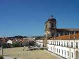
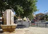
Alcobaça is a municipality and a city in the district of Leiria and subregion Oeste, in Portugal, formerly included in the province of Estremadura. The city grew along the valleys of the rivers Alcoa and Baça, from which it derives its name. The municipality has a total population of 55,269 inhabitants and a total area of 408.1 km². The city itself has a population of 6,232 inhabitants. The city of Alcobaça became notable after the first king of Portugal, Afonso Henriques, decided to build there a church to celebrate the conquest of Santarém to the Moors, in 1147. The church later evolved into the Monastery of Alcobaça, one of the most magnificent gothic monuments in the country. In the church are the tombs of King Peter I and his murdered mistress Inês de Castro. Over the centuries this monastery had an important role on Portuguese culture. A few kilometers to the north of Alcobaça is located the Monastery of Batalha, another wondrous gothic building constructed in memory of a different important battle, that of Aljubarrota. To the west of Alcobaça is the well-known fishing village of Nazaré. To the south is Caldas da Rainha and the quaint medieval town of Óbidos that is an attraction for any tourists that enjoys a true glimpse of the past. Also to the south is the town of Porto de Mós with its fanciful rebuilt castle.
History
A town that only became notable in the 12th century when it became the site for the construction of Portugal's largest church. In the month of March in 1147 the fledgling King, Dom Afonso Henriques, defeated the Moors by capturing the city of Santarém. As a suitable memory to this splendid victory he vowed to build a magnificent home for the Order of Cistercians. It took another 76 years before this task was completed. The monarchy continued to endow the Monastery of Alcobaça with further construction and 60 years later King Dinis built the main cloister but it was only in 1252 that the Monastery was inaugurated within the church. In the church are the tombs of King Peter I and his murdered mistress Inês de Castro and with it the story of the tragic liaison between Pedro and his ever-lasting love for Inês. Forced at an early age by royal duty he had to marry Constanza, the Infanta of Castile. She died within a short time of the marriage ceremony and created the opportunity for Dom Pedro to escape with his true love and live in the city of Coimbra. King Afonso IV his father, believing that the family of Inês to be a threat to his own kingdom had her murdered. Shortly after the death of his father Dom Pedro declared that he had married Inês in a prior secret ceremony in Bragança, promptly taking revenge on the killers in a very gruesome manner and exhumed her body. He presented the embalmed corpse at court with a crown on her head and demanded that all his courtiers kneel and individually pay homage to her decomposed hand. Today, their ornate tombs face each other so that on Judgment Day his first sight would be of his beloved Inês. During the following centuries the monks from this monastery had an influencing effect on Portuguese culture. Notably, in 1269 they were the first to give public lessons to their flock, and later they produced the authoritative history on Portugal in a series of books. In 1810 the invading French pillaged the Abbey taking with them most of the many treasures including a noteworthy library. Whatever the items remaining were then later stolen in 1834 during an anti-clerical riot and the extinction of religious Orders in Portugal.
.
Parishes
Alcobaça; Alfeizerão; Alpedriz; Bárrio; Benedita; Cela; Coz; Évora de Alcobaça; Maiorga; Martingança; Montes; Pataias; Prazeres de Aljubarrota; São Martinho do Porto; São Vicente de Aljubarrota; Turquel; Vestiaria; Vimeiro
..
.
 |
 |
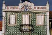 |
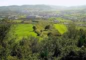
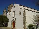
Alenquer is a municipality in Portugal with a total area of 304.2 km² and a total population of 42,932 inhabitants. The municipality is composed of 16 parishes, and is located in the District of Lisbon.
History
The name Alenquer is said to derive from the Germanic "Alen Ker" meaning the Temple of the Alans, and the city itself is, legend says, is said to have been established by the Alanian king Attaces. The Alans' dog, the Alaunt, is represented in the city's coat of arms. This is nothing but a legend, though, as there have been settlemenst in the area before Roman times, and these were also established there, namely in the location of Ierabriga or Lerabriga. The city's castle, however, may have been established by the Alans, or maybe the Visigoths. Alenquer received its Foral in 1212 by the hand of Infanta Sancha, Lady of Alenquer, daughter of King Sancho I of Portugal.
Parishes
Abrigada; Aldeia Galega da Merceana; Aldeia Gavinha; Cabanas de Torres; Cadafais; Carnota; Carregado; Meca ; Olhalvo; Ota; Pereiro de Palhacana; Ribafria; Santo Estêvão (Alenquer); Triana (Alenquer); Ventosa; Vila Verde dos Francos
..
|
|
|
 |
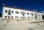
Arruda dos Vinhos is a municipality in Portugal with a total area of 78.0 km² and a total population of 11,210 inhabitants. The municipality is composed of 4 parishes, and is located in the District of Lisbon.
Parishes
Arranhó; Arruda dos Vinhos; Cardosas; Santiago dos Velhos
..
.
 |
 |
 |
..
 |
|
 |

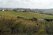
Cadaval is a municipality in Portugal with a total area of 174.9 km² and a total population of 14,385 inhabitants. The municipality is composed of 10 parishes, and is located in the District of Lisbon.
..
 |
|
 |
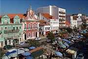
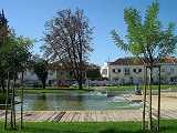
Caldas da Rainha is a city in Portugal. The city serves as the seat of the larger municipality of the same name and is the capital of the Comunidade Urbana do Oeste (Urban Community of the West). The city proper has a population of 25,316, ranking 40th in population among Portuguese cities. The entire municipality has 48,846 residents. The city is best known for its hot springs and pottery. The city was founded in the 15th century by Queen Leonor, who established a hospital at the site of some therapeutic hot springs. The Hospital Termal Rainha D. Leonor is one of the oldest institutions of its kind in world, with five centuries of history. The city's name means "Queen's Hot Springs" or "Queen's Spa". Caldas da Rainha is home to many arts-related institutions. There are numerous museums in the city, mostly related to ceramics and sculpture. The city is home to a major arts and design school, as well as a school of ceramics. In 2008, the town council inaugurated a new cultural center.
.
History
Caldas da Rainha was founded by Queen Leonor, wife of King João II. One day in 1484, while traveling from Óbidos to Batalha, she found a group of peasants bathing in foul-smelling waters by the roadside. She stopped to inquire about this oddity and was told that the waters possessed curative powers. She decided to try them for herself. She was pleased to find that she was quickly relieved of some affliction she had been suffering (exactly what is not known). On that site, the queen ordered a thermal hospital built so that others may enjoy the relief that she felt. Construction began the following year, 1485. Although the first patients were admitted in 1488, construction was not completed until about 1496 or 1497. The name of the settlement that grew up around the site (Caldas da Rainha), refers to both its founder and the reason for its existence. On March 21, 1511, King Manuel conferred the status of town (Portuguese: vila) upon Caldas da Rainha. The town was elevated to the status of city (cidade) in September 1927. In the early 20th century, it had a significant artistic and intellectual life. Caldas da Rainha's coat of arms was granted by Queen Leonor, before municipal coats of arms were typically used in Portugal. Because of its early introduction, several elements of the arms violate Portuguese heraldic standards. For example, Portuguese coat of arms typically feature a mural crown, made up of brick towers. Caldas da Rainha's arms feature a gold crown. The arms lack the typical banner bearing the municipality's name. The shield is much longer than the normal 8:7 ratio. The two smaller shields surrounding the main shield are also not in keeping with Portuguese heraldic rules.
.
A-dos-Francos; Alvorninha; Carvalhal Benfeito; Coto; Foz do Arelho; Landal; Nadadouro; Nossa Senhora do Pópulo; Salir de Matos; Salir do Porto; Santa Catarina; Santo Onofre; São Gregório; Serra do Bouro; Tornada; Vidais
.
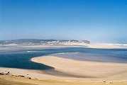
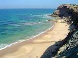
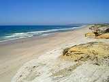
Foz do Arelho is a beach that is about 10 kilometres (6.2 mi) from the centre of town. The Lagoa de Óbidos, which empties into the Atlantic Ocean, is a lagoon located on the border with Óbidos near Foz do Arelho. Salir do Porto is a beach located on the opposite side of Sao Martinho do Porto that is within the Caldas da Rainha municipality.
..
|
|
|
|

Lourinhã is a municipality in Portugal with a total area of 147.2 km² and a total population of 24,601 inhabitants. The seat of the municipality is the village of Lourinhã, with a population of 8,800 inhabitants. The municipality is composed of 11 parishes, and is located in the District of Lisbon. The area of Lourinhã is known by the Late Jurassic findings of dinosaurs and other fossils, and give the name for Lourinhã Formation. The Museu da Lourinhã holds the main dinosaur collection.
History
The name Lourinhã possibly originated in the period of Roman domination, when a villa was located in the area. The origin of the medieval village is linked to Jordan, a French knight who took part in the successful Siege of Lisbon in 1147. King Afonso Henriques granted Jordan the region of Lourinhã as fief and allowed him to grant a foral (letter of feudal rights) to its settlers in 1160. The name Lourinhã may be related to the origin of its feudal lord, since Jordan was from the Loire region in France. The rights of Lourinhã were confirmed by letters of King Sancho I in 1218 and again by Afonso III in 1258. The parish of Lourinhã became one of the richest of the Lisbon Diocese, as reflected by its main church, a fine example of 14th-century Portuguese Gothic architecture. The Gothic works of the main church were sponsored by Lourenço Vicente, a Lourinhã-born Archbishop of Braga who received the village as a donation of King John I in 1384. In the 16th century, the Franciscan monastery of Santo António (1598) and a Misericórdia Church and Charity (1586) were founded in Lourinhã. The Misericórdia (Mercy), a religious charity, now houses a museum with outstanding Renaissance paintings. The most important paintings are by the hand of a mysterious early 16th-century painter, dubbed the Master of Lourinhã (Mestre da Lourinhã). Starting at the end of the 19th century, the infrastructure of the municipality was modernised with roads, canalised water and electric light, as well as improvements in the educational system. The economy depended mostly on agriculture and fishing. Tourism is an increasingly important source of revenue, due to the municipality's extensive, picturesque beaches and, more recently, by the paleontological remains, which include fossilised bones, footprints, eggs and even embryos from Jurassic dinosaurs. Many of which can be seen nowadays at the local museum, Museu da Lourinhã.
Atalaia; Lourinhã; Marteleira; Miragaia; Moita dos Ferreiros; Moledo; Reguengo Grande; Ribamar; Santa Bárbara; São Bartolomeu dos Galegos; Vimeiro
.
Lourinhã has 12 km of coastline with several popular beaches.Praia de Areal; Praia da Areia Branca; Praia do Caniçal; Praia de Paimogo; Praia de Vale Frades; Praia de Porto das Barcas; Praia da Peralta
.
|
|
|
|
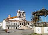

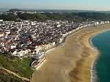
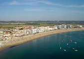
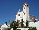
Nazaré is a town and a municipality in Portugal with a total area of 82,4 km² and a total population of 14,904 inhabitants. It is in subregion Oeste and Leiria district. According to legend, the town derives its name from a statue of the Virgin Mary brought here by a monk in the 4th century from Nazareth, Palestine. It has become a popular tourist attraction, advertising itself as a picturesque seaside village. Located on the of the Atlantic coast, it has long sandy beaches that are crowded with tourists in the summer. The town used to be known for its traditional costumes worn by the fishermen. Their wives were dressed in black, wearing the traditional headscarf and embroidered aprons over seven flannel skirts in different colours. These dresses can still occasionally be seen. The town consists of three sections: A Praia (along the beach), O Sítio (the old town, on a hilltop) and Pederneira (on another hilltop). The A Praia and O Sítio areas are linked by the Nazaré Funicular, a funicular railway. The original settlement was in Sítio on the rock face 110 m above the beach. It was the inhabitants safe base against raids by Algerian, French, English and Dutch pirates that lasted even till the beginning of the 19th century. The Church of Nossa Senhora da Nazaré was built to commemorate a legendary miraculous intervention by the Virgin in saving the life of a 12th century knight. The municipality is composed of 3 parishes, and is located in the District of Leiria. It is one of the many popular seaside resorts in the Costa de Prata / Silver Coast of Portugal.
.
Famalicão; Nazaré; Valado dos Frades
.
|
|
|
|
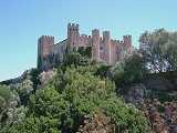
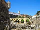
Óbidos is a town (
.
History
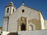
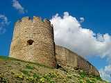
The name "Óbidos" probably derives from the Latin term oppidum, meaning "citadel", or "fortified city". Roman occupation of the area has been recently confirmed by archaeological excavations, which revealed the existence of a Roman city very close to the hill where the village is located. This Roman settlement is most certainly the mysterious Eburobrittium, cited by Pliny the Elder as situated between Collipo (near present-day Leiria) and Olisipo (Lisbon). Until now the surveys have revealed the rests of the forum, baths and other buildings. After the fall of Roman domination, the region must have come under the influence of the Visigoths, although material evidence is lacking. The Roman town of Eburobrittium was probably abandoned in the 5th century for the more secure hill where Óbidos is located. Sometime after 713 the Moors established a fortification on top of the hill. A Christian community of Mozarabs lived in the Moncharro neighbourhood. The area was taken from the Moors by the first King of Portugal, Afonso Henriques, in 1148. Tradition states that one knight, Gonçalo Mendes da Maia, was responsible for the successful storming of the Moorish castle. The retaking of Óbidos meant the end of the Reconquista of the Estremadura region, after the conquests of Santarém, Lisbon and Torres Vedras. The village received its first foral (charter) in 1195, under the reign of Sancho I. In 1210, King Afonso II donated the village to his wife, Queen Urraca. Since then Óbidos has often belonged to the Queens of Portugal, giving rise to its informal title as Vila das Rainhas (Queens' village). Several Queens enriched the village with donations from the Middle Ages until the 16th century. The castle of Óbidos and the walls of the village were remodelled under King Dinis I. The village was also enlarged around this time, with settlements created outside the walls. The massive keep of the castle is attributed to a building campaign sponsored by Fernando I (late 14th century). The Santa Maria Church of Óbidos was the setting for the wedding of King Afonso V with his cousin, Princess Isabel, on August 15th, 1441, when they were both still children of 9 and 10. The town has a magnificent castle, now hosting a pousada. The municipality is also home to the well known and prestigious Praia D'el Rey golf complex, one of the top golf resorts in Europe.
.
Óbidos has 9 civil parishes: A dos Negros; Amoreira; Gaeiras; Olho Marinho; Santa Maria; São Pedro; Sobral da Lagoa; Usseira; Vau
Praia D'el Rei, Bom Sucesso, Rei Cortiço
.
|
|
|
|

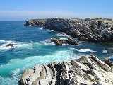
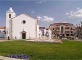
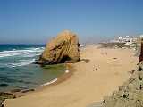
Peniche is a seaside municipality and a city in Portugal, with approximately 28,164 inhabitants in the municipality and about 15,600 in the city of Peniche. The Berlengas islands are part of the municipality, off the coast of Peniche. They are one of the world's first protected areas, the Berlengas nature reserve. During summer, the islands can be visited taking a ferryboat from Peniche. Peniche is known for its long windy beaches, sought for recreational activities and sports as surf, windsurf or kite surf. Peniche has very good waves. Supertubos is the most popular wave in the region, with very fast and powerful (tubular) waves, one of the best in Europe; some call it the "European Pipeline". Peniche, with its typical harbour, its white windmills and chapels and large sand beaches has inspired notorious painter artists like Maurice Boitel.
.
History
The name Peniche seems to have its origin in the Latin word peninsula (paene + insula) which literally means "almost an island". This origin, apparently proved through known historical documentation, indicates a cyclical picture of a certain insularity, probable due to the rhythm of the tides and whose memory has perpetuated in a place name which, with time, has evolved to the present word “Peniche”. The main known pre-historical stations in the municipality correspond to cave occupations. An important set of sites is located southeast of the municipality, in the Cezaredas Plateau. However, the most important pre-historical station in the municipality is the
.
Ajuda; Atouguia da Baleia; Conceição; Ferrel; São Pedro; Serra d'El-Rei
Porto de Areia Sul; Cova de Alfarroba; Gambôa, Peniche de Cima, Baleal Campismo, Baleal Sul, Baleal Norte, Supertubos, Consolação; Sao Bernardino; Molhe Leste
.
|
|
|
|
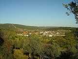
Rio Maior is a municipality in Portugal with a total area of 272.8 km² and a total population of 21,621 inhabitants. The municipality is composed of 14 parishes, and is located in the district of Santarém..
Alcobertas; Arrouquelas; Arruda dos Pisões; Asseiceira; Assentiz; Azambujeira; Fráguas; Malaqueijo; Marmeleira; Outeiro da Cortiçada; Ribeira de São João; Rio Maior; São João da Ribeira; São Sebastião
|
|
|
|

.
History
During the Peninsular War, Sobral was on the Lines of Torres Vedras, a line of forts planned by the Duke of Wellington to protect Lisbon. In October 1810, a French army led by André Masséna approached the Lines, finding that the Portuguese had subjected the area in front of them to a scorched earth policy. After a skirmish at Sobral on October 14, the French found they could go no further. Charles Oman writes "On that misty October 14th morning, at Sobral, the Napoleonic tide attained its highest watermark."São Quintino; Sapataria; Sobral de Monte Agraço
.
São Quintino; Sapataria; Sobral de Monte Agraço
.
|
|
|
|
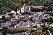
Torres Vedras is a city and a municipality in the district of Lisbon, Portugal, about 50 km north of Lisbon. The municipality covers an area of 405.89 km² distributed over 20 freguesias. It borders to Lourinhã to the north, Alenquer to the east, Sobral de Monte Agraço to the southeast, Mafra to the south and the Atlantic Ocean to the west. To the south of the municipality run the lines of Torres Vedras, constructed on the orders of the Duke of Wellington in 1809-10.
.
The municipality is subdivided into 20 parishes.
A dos Cunhados; Campelos; Carmões; Carvoeira; Dois Portos; Freiria; Maceira; Matacães; Maxial; Monte Redondo; Outeiro da Cabeça; Ponte do Rol; Ramalhal; Runa; Santa Maria do Castelo e São Miguel; São Pedro da Cadeira; São Pedro e Santiago; Silveira; Turcifal; Ventosa
Praia da Assenta Sul; Praia da Assenta Norte; Praia de Cambelas; Praia da Foz do Sizandro; Praia Azul; Praia da Amoeira; Praia Formosa; Praia do Guincho; Praia da Azenha; Praia de Santa Helena; Praia do Centro; Praia do Norte; Praia da Física; Praia do Pisão; Praia do Mirante; Praia do Navio; Praia da Vigia; Praia da Mexilhoeira; Praia do Seixo; Praia de Santa Rita Sul; Praia de Santa Rita Norte; Praia de Porto Novo
.
® Copyright: Cenario Oeste - Portugal Silver Coast Properties - AMI 7874